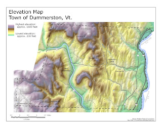
Hyposometric maps are used in topographic surveying and they show elevation by using countours, shading, tinting, etc. In this specific map of Dummerston Vermont, they used a variety of colors and isohypses to display and distinguish between elevation as low as 230 feet and up to 1680 feet. Unlike down here in flat Florida, up in mountanious Vermont, I'm sure Hyposometric maps are used very often.
Thursday, December 3, 2009
Subscribe to:
Post Comments (Atom)

No comments:
Post a Comment